History of Horseshoe Ranch
In 2015 Cornerstone Environmental Consulting, LLC (Cornerstone) provided archaeological monitoring services to the Arizona Game & Fish Department (AGFD) while they were replacing and updating the ranch’s water system (Edwards et al. 2015). Horseshoe Ranch is a beautiful ranch headquarters complex located south of Cordes Junction and east of Interstate 17 in the Bloody Basin of central Arizona that is wholly surrounded by the 71,000-acre Agua Fria National Monument (Figure 1). The AGFD acquired the approximately 200-acre property in 2011, which sits on arable land at the confluence of Indian Creek with the Agua Fria River. http://www.azgfd.gov/outdoor_recreation/watchableWildlife/horseshoeRanch.shtml
 Figure 1. 2013 photo of Horseshoe Ranch from Bloody Basin Road.
The distinct paucity of sources pertaining to the history of the Bloody Basin region is generally known to historians, and the development of the Horseshoe Ranch property is just as elusive. Luckily, the author was able to correspond directly with Shawn Wingfield (Louis Wingfield’s daughter) and Dean Cameron, both of whom lived at the ranch for 34 years, raised their family there, and generously shared their experiences from that time. This article also cites an unpublished history of Horseshoe Ranch by Rita Grandrud (n.d.), the archaeological survey report for the Horseshoe Ranch Headquarters (Rayle and Watkins 2011:9-13), a historic context on cattle ranching in Arizona published by the United Producers and Consumers Cooperative (UPCC n.d.), and online resources including articles and advertisements.
Horseshoe Ranch was first established in the early 1880s by Philadelphia cattle rancher William N. Mitchell, who moved to the Bloody Basin area in 1877. Grandrud (n.d.:2) describes Horseshoe Ranch as a “large and well-stocked cattle ranch” on the banks of the lower Agua Fria River near Antelope Station (now known as Cordes ). The ranch was an itinerant operation for many years and received its name from the use of a “U” or horseshoe-shaped brand.
In December 1889, William Mitchell's younger sister, Catherine Scott, purchased the first land patent (BLM serial no. AZAZAA 014710, issued 12/16/1889) in the Bloody Basin area, which included 160 acres where the Horseshoe Ranch headquarters is located today. Mitchell and Scott owned rights to the Horseshoe brand until 1895, when Mitchell sold the property due to Scott’s failing health.
After 1895, the property and the Horseshoe brand were owned by several individuals, for multiple short periods. Owners of the property between 1896 and 1910 included the Fisher brothers (Ralph and Clark) and Lou Harmon. Harmon was already a well-known cattle rancher in the Prescott area when he acquired the ranch in 1910. Less than a year passed before Harmon sold the property to former Yavapai County sheriff, George Ruffner, and his friend and business partner, Ralph “Charlie” Hooker. Two years later, Ruffner sold his portion of the business to Al Kellog, who ran the ranch with Hooker until 1915 when the property was acquired by pioneer cattlemen and brothers, Bob, Will, and Walt Coburn.
The Coburns came to Arizona from Montana in the mid-1910s and formed the Coburn Brothers Cattle Company. During their tenure at the ranch, the Coburns acquired several small parcels of land on the Tonto and Prescott National Forests and operated ten ranches east of the Verde River near Prescott and Globe. By 1920, the men had forest permits for nearly 8,000 head of cattle and had six brands recorded with the state (ALSB 1920). It is also estimated that the men had more than 5,000 cattle on leased lands between the Horseshoe Ranch property and the east side of the Verde River. Bloody Basin rancher and entrepreneur Henry Cordes described the Coburn’s operation as “strictly a pack outfit operation” that was “90 percent inaccessible for wagons” (Grandrud n.d.). Drought and logistical problems forced the Coburn Brothers Cattle Company into bankruptcy in the mid- to late 1920s. At that time, the bank reclaimed the Horseshoe Ranch property and hired Gila County ranchers, William A. and Neil Ryan, to drive the 1,000 to 3,000 head of cattle to the railroad siding at Mayer (as told to Shawn Wingfield Cameron by Frank Polk; pers. comm. to Josh Edwards, February 19, 2019). The ranch was finally split into smaller parcels and sold by the bank within the next two years.
In 1918, the Arizona State Land Department (ASLD) decided to claim all of the public domain land on Perry Mesa as part of institutional land grants that were given to Arizona per the State Enabling Act of 1912. The Coburn brothers were able to hold on to 160 acres of private land, which was then surrounded by thousands of acres of state land that the Coburns leased for grazing (Grandrud n.d.). Sometime after 1918, the Coburn brothers and other ranch owners purchased all or part of the three sections of land that surrounded the 160-acre homestead (Grandrud n.d.).
Portions of the ranch were eventually purchased by an association of sheep ranchers in the 1940s, including two well-known Arizona sheep growers, Lou Charleboise and Tony Manterola. The ranch was next acquired by sheep and cattle rancher John Hennessy in the late 1940s or early 1950s. Little is known about Henessey’s tenure at the ranch. However, it is believed that Hennessy was the first rancher to establish a fixed ranching operation on the property. It is believed that Hennessy is responsible for building a small adobe residence on the property, and for constructing the original alignment of Bloody Basin Road to provide access to his newly constructed headquarters. John W. Hennessy held the Red Hill Allotment in 1949, which he used for sheep grazing. He listed the Verde River Sheep Bridge as a range improvement on grazing permits issued to him by the Tonto National Forest in 1949 and 1952. Hennessy was born in Flagstaff in 1902, and died February 21, 1958.
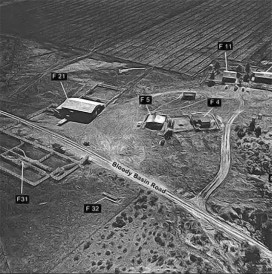
In 1956, John Hennessy sold the ranch to wealthy Pennsylvania industrialist Bernard “Bernie” Erskine. Erskine added numerous buildings to the headquarters of the ranch between 1956 and 1958, including a barn and outbuildings, a manufactured home, and a one-room residence that he used during overnight visits. The one-room residence was demolished in 1968 and replaced by a two-bedroom building (Figures 2 and 3: Feature 4), the manufactured home (Feature 12) was remodeled and enlarged by Shawn and Dean Cameron prior to 1977, and Louis Wingfield slightly remodeled the adobe house (Feature 11) and the tin outbuilding prior to 1970 (Shawn Wingfield and Dean Cameron pers. comm. to Josh Edwards, February 19, 2019). Many of these structures are visible in an aerial photograph of the ranch from 1960 (Figures 2 and 3). The barn and residence remain on the property today.
 Figure 2. 1960 aerial photo of Horseshoe Ranch, facing south-southeast (photo credit: Grandrud n.d.).

Figure 3. 1969 photo of Horseshoe Ranch, facing east (photo credit: Matt Culley, Sharlot Hall Museum).
Erskine sold the Horseshoe Ranch to Louis and Billie Wingfield in January of 1960. At that time the ranch encompassed “2,900 acres of deeded land, some of which lay in odd areas of the ranch” (Shawn Cameron pers. comm. to Josh Edwards, February 12, 2019). Shawn Cameron (Figure 4) also stated that she was “never aware of another headquarters than where we lived. My grandfather reported information from when he stayed at the headquarters around 1914 while traveling horseback through Arizona to southern Arizona to work at the Chiricahua Cattle Company. He took a bus from Globe to look at the Horseshoe Ranch when it was for sale about 1921-1922” (pers. comm. to Josh Edwards, February 19, 2019).

Figure 4. 1972 photo of Louis Wingfield and Shawn Cameron at Horseshoe Ranch during a “Cattlegrowers” tour of the ranch (photo credit: Matt Culley, Sharlot Hall Museum).
The Wingfields were prominent Arizona cattle ranchers and became the first non-absentee owners of the property, although they did not live there full-time until they built their home there in 1968. Billie Wingfield's father was John Osborn, an early Arizona cattleman and general manager of the Chiricahua Cattle Company. Shawn Cameron states that her grandfather, and Frank Polk of Mayer, “knew some of the cowboys that gathered 10,000 head and drove them to the railroad siding in Mayer. Henry did not ranch in Bloody Basin but on the west side of what is now I-17 toward the Bradshaw Mountains, although he had a small pasture just east of the highway” (Shawn Wingfield and Dean Cameron pers. comm. to Josh Edwards, February 12 and 19, 2019).
The Wingfield family owned other ranches in the Bloody Basin area including Cavness and Rincon Ranches, the A. Y. Ranch between Cleator and Crown King, and the Valley Ranch south of Grand Canyon (originally purchased by John Osborne in 1940). Wingfield was an active member of the Arizona Cattlegrowers Association, served as president of the Yavapai Cattlegrowers Association in 1977, and worked closely with the ASLD, Bureau of Land Management (BLM), and the United States Department of Agriculture (USDA) Forest Service to insure attainment of the ranch’s potential. Louis’ son-in-law, Dean Cameron, who also served as the president of the Yavapai Cattlegrowers Association in 1983, worked the ranch and was the “hands on” manager who made many ranch decisions and physical changes to the property. Dean and Shawn Cameron were married in the home in 1970 and lived at the ranch for 24 years.
Louis Wingfield and Dean Cameron made numerous changes to the property between 1960 and 1993, including improving the existing water supply, constructing the main building and swimming pool (1968; Figure 5), and adding fencing (Figures 2 and 3). All the irrigated pastures were there when the ranch was purchased by the Wingfield. They were initially “irrigated from the pond and filled by the pump in the field. Water was released from the pond down a ditch and the fields were row irrigated with pipes. In the late 1970s Dean rebuilt the Silver Creek Gravity Flow Water Line so it had enough gravity pressure to operate sprinkler systems in the fields without electricity” (Shawn Cameron, pers. comm. to Josh Edwards, February 12, 2019).

Figure 5. 2013 photo of swimming pool from main house.
Louis and Dean also added numerous outbuildings and remodeled or demolished and rebuilt many of the buildings that were built by Erskine (Figures 6 and 7). Much of the current landscaping was completed sometime between 1970-72. Dean Cameron used the family’s D-7 Caterpillar tractor to realign Bloody Basin Road south of the headquarters around 1986-1987. This change diverted traffic around the historical Agua Fria River crossing and away from the family’s home. Currently, the original alignment of the Bloody Basin Road serves as the property’s main driveway. Dean Cameron also added the field that is west of the river around 1988.

Figure 6. 2013 photo of ranch headquarter complex.
Download Horseshoe_Ranch_History_040219.pdf
- Tagged In: Agua Fria National Monument, Arizona, History

Joshua S. Edwards
Josh is the Principal Investigator for Cornerstone Environmental in Flagstaff, Arizona. He is an archaeologist, geomorphologist, and faunal analyst specializing in research topics oriented toward Southwest prehistory. This has included research on changes in prehistoric settlement patterns and subsistence strategies, anthropogenically induced paleoenvironmental change, and fluvial system dynamics and their effect on cultural landscapes. His work has been geographically focussed in Arizona and western New Mexico, and includes projects in California, Nevada, Colorado, Utah, Wyoming, and Texas. Also having a passion for history, Josh loves reading about local historical events and people. This has led him to learn the intricacies of historic preservation. Applying these principals has been an ongoing challenge and has fulfilled his desire to continue learning and expanding his abilities within his academic and professional field.