Obsevatory Mesa
In 2013, Cornerstone archaeologists surveyed of 2,260 acres of State land on Observatory Mesa, that is partially within and immediately northwest of the city limits of Flagstaff (Figure 1). The City of Flagstaff purchased the land using funding from the Arizona Preservation Initiative, with the intent of preserving the project parcels in perpetuity. The Arizona Preservation Initiative seeks to provide Arizonans with pristine views, enhance land values, retain essential wildlife corridors, create environmentally sensitive recreational opportunities, and preserve open space without air or light pollution.
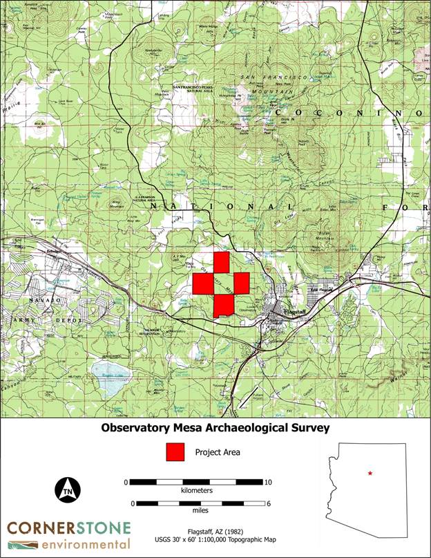
Figure 1. General location of the project area.
The archaeological survey was conducted prior to the sale of the land, and resulted in the recording of six archaeological sites. One site is a prehistoric flaked stone scatter, representing a raw material testing and procurement area, and the other five sites are historic Euroamerican refuse scatters dating between 1915-1955. Prehistoric people utilized resources on and around Observatory Mesa since at least Archaic times, but no permanent habitation sites are known to exist on the mesa.
During the Historic period, several important early transportation corridors passed near the project area. The 1879 General Land Office (GLO) maps for the area show the Beale Wagon Road (1859) to the northeast and the Overland Road (1863) to the south (Figure 2). The even-numbered sections of Townships 21 and 22 were withdrawn as a part of the San Francisco Mountains Forest Reserve on August 17, 1898, and the odd-numbered sections were included on April 12, 1902.
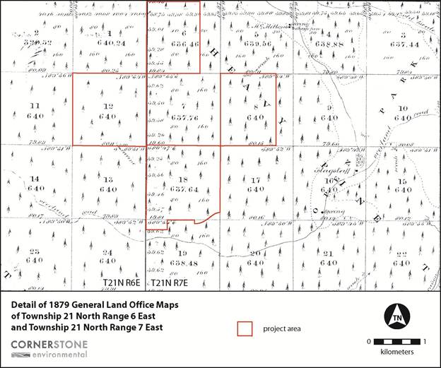
Figure 2. Detail of the 1879 GLO maps of the project area and surroundings.
The arrival of the A&P Railroad in 1882 led to an expansion of ranching and logging in the Flagstaff area. Although Observatory Mesa was likely clear cut of trees prior to 1900, the Coconino National Forest's Burrall Timber Sale Control Atlas indicates that the area was logged again between 1926 and 1928. The area was also used extensively for grazing, the holding of livestock for shipments, and to a lesser extent for agriculture.
The Santa Fe Railroad, two logging railroads, and a number of main and secondary wagon roads traverse the area. In addition, rights of way for county roads also covered lands in all directions from the town site. From a grazing standpoint, the area was seen as very valuable, the many fenced pastures being used principally for the fattening and holding of beef cattle and sheep for shipping from Flagstaff. In fact, the reason sheep were not allotted range to any extent on the township is due to its heavy use in connection with the holding of stock for shipments. The presence of water in stock tanks, the good forage, and the proximity to market and shipping facilities made the area very valuable for ranching.
Dry farming methods were used as no water was available for irrigation. A typical ranch, two miles east of Flagstaff, under average climatic conditions, yielded approximately 30 bushels of oats valued at 75¢ per bushel, or 1½ tons of oat hay valued at $20.00 per ton, or three tons of potatoes valued at $1.75 per 100 pounds, to the acre. The market at Flagstaff was never fully supplied with forage, potatoes, etc., from local ranches, and the high prices gave good returns when the years were favorable. The welfare and prosperity of the town was not dependent upon the surrounding agricultural lands, as the town was built up by stock raising and lumbering operations.
Related links:
https://land.az.gov/sites/default/files/documents/files/API_BACKGROUND_INFO.pdf
Download Observatory_Mesa_Project_121213.pdf- Tagged In: Archaeology, Arizona Preservation Initiative, Flagstaff

Cornerstone Environmental
Cornerstone approaches every project from the perspective of our client’s needs. We provide cost effective solutions by fulfilling compliance objectives that meet project goals through effective communication and timely deliverables. Our goal to build trust through integrity provides a sound foundation for a safe, innovative, client-focused company. Cornerstone provides an innovative approach to environmental regulation in the greater American Southwest using technically sound, technically savvy methods.